
Upcoming events
- GLOBALISE seminar: CAPASIA, The Asian Origins of Global Capitalism
Join us for a seminar presented by the CAPASIA and GLOBALISE projects!
Date: Tuesday, 21 May 2024
Time: 15:00 – 16:00 CEST, drinks afterwards
Location: Room 2.18 of the Spinhuis, Oudezijds Achterburgwal 185, 1012 DK Amsterdam
Link for remote participation: https://uva-live.zoom.us/j/83308701372Speakers
- Maarten Draper (European University Institute)
- Sebastian Majstorovic (European University Institute)
Referent
- Luc Bulten (Radboud University)
Seminar overview
The CAPASIA project analyzes approximately 150 European ‘factories’ established in maritime Asia between 1500-1800. It views these not just as trade locations, but as vibrant hubs of material and information exchanges between Asians and Europeans. The project uses the factories as a lens to explore the Asian origins of global capitalism. In their talk, Maarten Draper and Sebastian Majstorovic will provide an overview of the aims and methodology of the CAPASIA project, including the development of a comprehensive database of these factories. They will also discuss how the CAPASIA and GLOBALISE projects align and build upon each other.
CAPASIA (https://www.capasia.eu/) is a five-year ERC-funded project hosted at the European University Institute in Florence. Its deliverables include a user-friendly website that will serve as a repository for data on the factories, a meeting place for scholars, and a medium for decolonizing histories of global capitalism. GLOBALISE (https://globalise.huygens.knaw.nl/), a five-year NWO-funded project based at the Huygens Institute in Amsterdam, focuses on making the VOC archives more accessible to researchers.
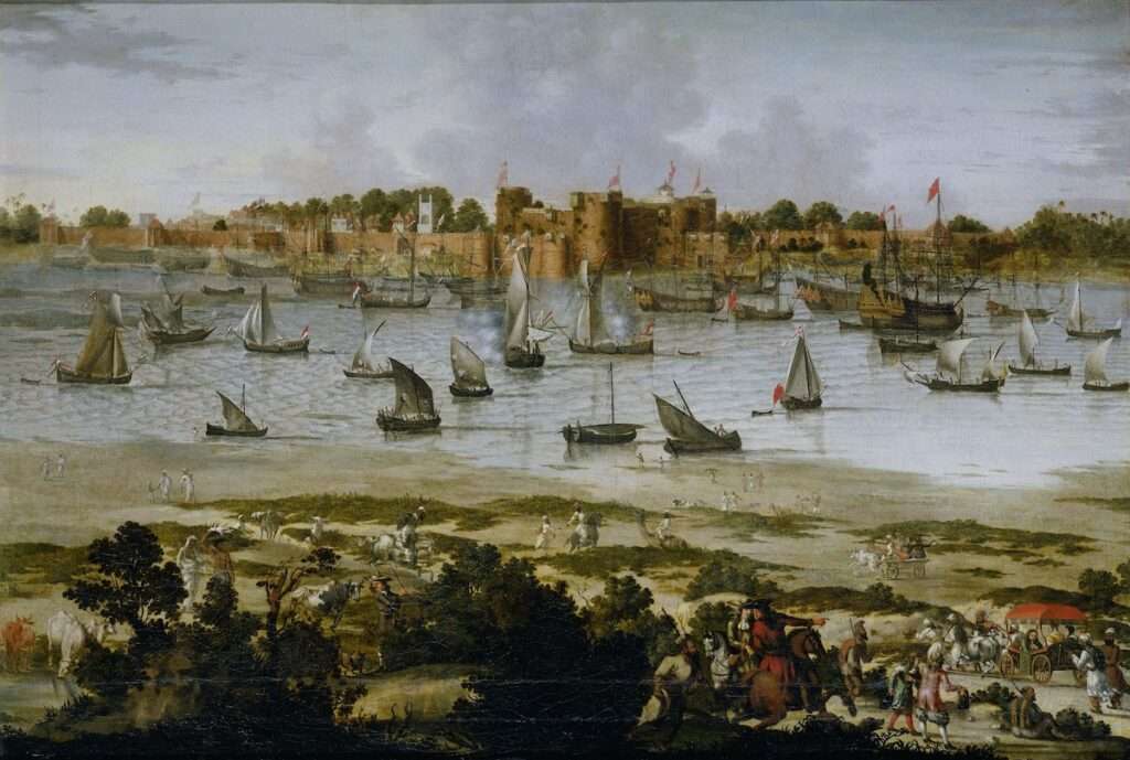
View of the Harbor of Sūrat (Gujarāt), anonymous, c. 1670 Rijkmuseum, SK-A-4778, CC0
Past events
- GLOBALISE Datasprint: What on Earth is This? Defining, Labeling and Classifying Early Modern Commodities
Date: Monday 4 December
Time: 13:00 – 16:15
Location: Room F0.01 at the Humanities Labs, University of Amsterdam (Bushuis, Kloveniersburgwal 48 Amsterdam).
Parallel sessions will be organised for online participants.
Registration: Eventbrite
Tools: Bring your own laptop!Are you a historian or a student of history at university with a keen interest in trade, material culture, commodity histories or just good old historical research? If yes, we at the GLOBALISE Project (KNAW Humanities Cluster), in collaboration with the CREATE Lab (UvA), invite you to participate in a workshop to contribute to and enrich our thesaurus of commodities traded in the early modern Indian Ocean world.
As part of our effort to contextualise the contents of millions of pages from the VOC archives, we are creating a glossary and taxonomy of hundreds of commodities that were traded by the Dutch East India Company and local communities. We plan to publish the first online version of the dataset shortly. Owing to the size of the Dutch East India Company archives, this makes this corpus the potentially single largest source available to uncovering the history of the region. For this reason, we believe that our commodities dataset will be of indispensable use for researching these archives and writing new histories of trade and consumption in the Indian Ocean in the period.
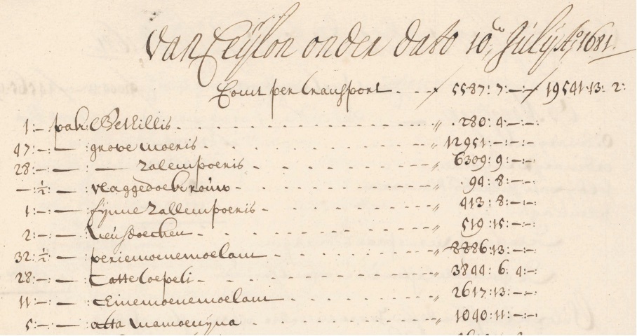
An example of a cargo list with textiles from Ceylon in the VOC archive, with several packs of bethilles, moeris, vlaggedoek, salempoeris, neusdoeken and periemoenemolam. Nationaal Archief, CC0. We would like to invite you to participate in a half-day datasprint where we will research the definition of commodities, scour the VOC archives and other sources to find alternative labels for these goods, and even categorise commodities in groups that would be interesting and valuable for your own research. This will be the perfect opportunity to sink your teeth into the archives of the Dutch East India Company, learn more about commodities that crossed the early modern seas, deploy your skills of historical research, interact with like-minded students and scholars, and contribute to the creation of a vital, shared resource.
Programme
13:00 – 13:15 Introduction
13:15 – 14:15 Sprint part 1
14:15 – 14:30 Break
14:30 – 14:45 Commodity Stories
14:45 – 15:45 Sprint part 2
15:45 – 16:15 Closing discussion - GLOBALISE HTR Launch
Date: Wednesday 4 October 2023
Time: 12:15 – 17:30 CEST
Location: International Institute of Social History, Cruquiusweg 31, 1019 AT Amsterdam
Registration (required): EventbriteGLOBALISE is pleased to announce that the first results of the project are now available to all. You are warmly invited to find out more at an event hosted by the International Institute of Social History in Amsterdam, on Wednesday 4 October 2023 from 12:15 to 17:30 CEST.
The program features the launch of a simple viewer for searching and browsing the transcriptions, and sessions in which the team will share updates on the project and future plans. Also, participants can search through the transcriptions in a hands-on workshop session (and perhaps find that one obscure reference they were looking for!). Finally, there will be short presentations of recent research with the VOC archives and time for discussion.
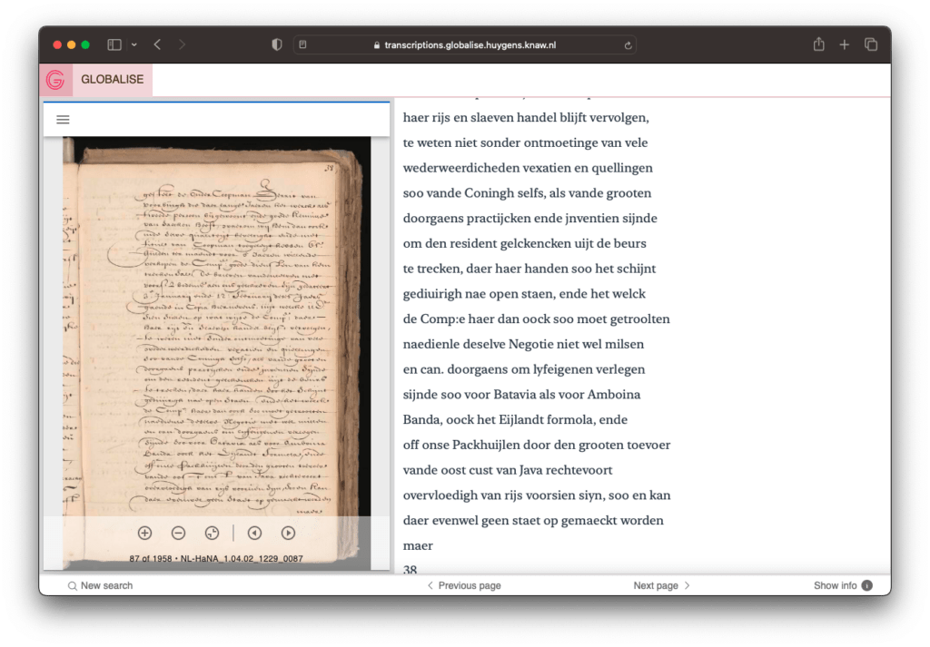
Screenshot of the GLOBALISE transcriptions viewer Please note that this event will be on site in Amsterdam.
Programme
12:15 – 13:00 Walk-in lunch (upon registration)
13:00 – 13:20 Introduction and updates
13:20 – 14:00 Workshop: working with the VOC transcriptions
14:00 – 14:15 Break
14:15 – 14:50 Research presentations
14:50 – 15:25 Reflections
15:25 – 15:50 Break
15:50 – 16:40 Looking ahead, Q&A
16:50 – 16:45 Closing remarks
16:45 – 17:30 Drinks
- GLOBALISE Datasprint: Mapping Places in the Indian Ocean World
In collaboration with the CREATE Lab, University of Amsterdam
Date: Monday 15 May 2023
Time: 13:00 – 17:00 CEST
Location: Bushuis F0.01, Kloveniersburgwal 48, 1012 CX Amsterdam
Registration: via EventbriteIntroduction
Historical places are important building blocks for the reconstruction of historical events. The GLOBALISE corpus of about 5 million pages from the VOC archives describes hundreds of thousands of events that took place over a period of two centuries in a large number of locations spread over a huge area around the Indian Ocean and Indonesian archipelago. Thanks to initiatives like the Atlas of Mutual Heritage and the World Historical Gazetteer, we can locate some of the places mentioned, but by no means all of them. Within GLOBALISE, we would like to bring as much of these locations to light as possible by creating a dataset that identifies and geolocates historical places mentioned in our texts. This is challenging, as disambiguation of spelling variations is not always easy, place names appear in different languages, change over time, and sources present ambiguous references to locations.
This datasprint aims to foster collaboration between historians, heritage professionals and data scientists for better availability of data on historical places. It intends to curate, publish, and link data on historical places collected by researchers within their own projects, as well as test and improve digital techniques to extract, structure, and share data on places. In addition to data creation, curation, and linking, this datasprint will offer a space to exchange knowledge and expertise on historical places and contexts, and digital techniques. We hope that by the end of the datasprint, all participants will have learned something, and that we will have generated valuable data on historical locations with which to improve our understanding of the early modern Indian Ocean and Indonesian archipelago worlds.
Sessions
The datasprint consists of three simultaneous sessions on georeferencing, data extraction, and data linking respectively. Everyone with an affinity or interest in (early modern) maps, history of the Indian Ocean World, or digital techniques for data extraction, is welcome to join regardless of technical / historical proficiency!
Georeferencing early modern maps
Chair: Jules Schoonman (TU Delft)
Preparation: None.
Tools: Your own laptop with an up-to-date browser (preferably Firefox or Chrome) with javascript enabled.Digitised historical maps can be challenging to read and compare to modern-day maps, due to their difference in style, orientation, map projection and more. In these scenarios, it is helpful to georeference a map by relating several points to geospatial coordinates. On the basis of this information, the map can be used as an overlay in interactive web maps or GIS-applications, allowing for direct comparison between then and now. Other use cases include drawing geospatial data on the historical map or, conversely, the vectorisation of its features. Traditionally, such methods require the creation of derivatives, duplicate server infrastructures, and the use of proprietary software–often not resulting in open and reusable data.
This session introduces Allmaps, a new set of open-source tools to georeference, view and explore digitised maps from institutions supporting the International Image Interoperability Framework (IIIF). Using the sub-collection of maps from the Atlas of Mutual Heritage originating from the National Archives, we will (1) learn about IIIIF and how to find the right endpoints, (2) georeference maps in the Allmaps Editor, (3) learn about the format of a Georeference Annotation, (4) view the map in the Allmaps Viewer, (5) explore other uses for georeferenced maps.

A Dutch Map of Buton Island from 1749 as an overlay on a modern map. (Source: Allmaps) Data extraction from early modern maps
Chair: Melvin Wevers (University of Amsterdam)
Preparation: None.
Tools: Your own laptop with an up-to-date browser (preferably Firefox or Chrome) with javascript enabled.A substantial collection of historical location data for the Indian Ocean and Indonesian archipelago worlds is already available, notably in the Atlas of Mutual Heritage database that provides useful metadata for visual sources such as old maps. We aim to expand on this by, for instance, identifying locations and other geospatial features on a selection of old maps from the National Archives. In this session we will first try to identify the kind of information that can be extracted from old maps (e.g. inhabited places, but also, for example, plantations, mills, and harbours) to come up with an initial annotation framework, after which we will annotate these maps ourselves. The resulting data can be a starting point for automating the information extraction from old maps further.
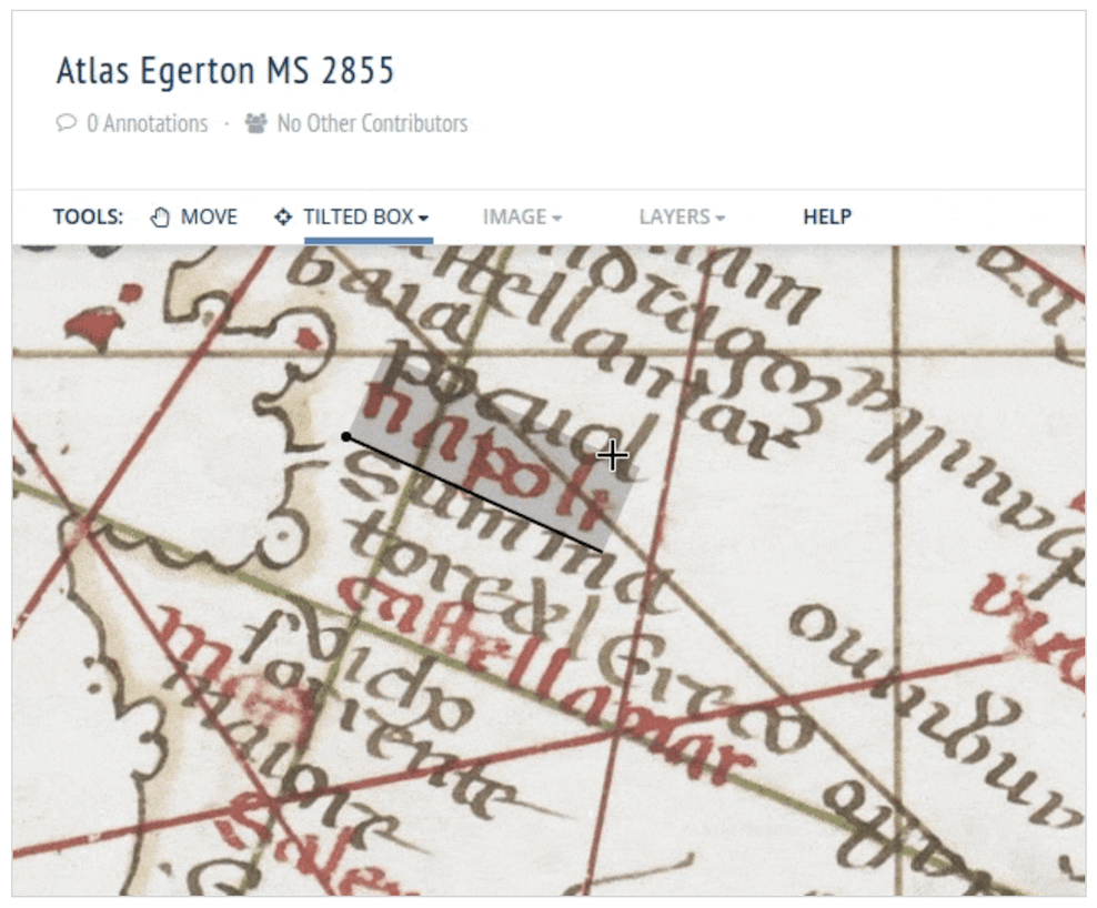
An example of an annotated place on an old map. (Source: Recogito) Curating and linking new places data(sets) via World Historical Gazetteer
Chair: Rombert Stapel (International Institute of Social History)
Preparation (optional): Bring your own data – a clean places dataset and access to your own dataset during session.
Tools: Your own laptop.Do you have a finished or in-progress dataset on historical locations originating from your research or personal project and would you like to be able to geolocate these places and enrich your data with other historical data? In this session, we will work together to curate locations datasets to then upload them to the World Historical Gazetteer database and link them to other places in the WHG index – generating new, accessible, and reusable data on historical places.

An overview of places from the Atlas of Mutual Heritage database indexed in the World Historical Gazetteer. (Source: World Historical Gazetteer) Programme
13:00 Introduction
13:45 Breakout sessions: start
15:00 Break
15:15 Breakout sessions: wrapping up
16:00 Session results and conclusions
16:30 Reflection
17:00 Drinks
- GLOBALISE seminar: Historical Events and Frames Annotation Processes
28 NOVEMBER 2022
- Jens Aurich (Junior Researcher | International Institute for Social History)
“Finding and Annotating Collective Labour Actions in Newspapers with INCEpTION” - Stella Verkijk (Developer | GLOBALISE)
“Towards Automatic Event Detection in VOC Documents”
Date: Monday, 28 November 2022
Time: 15:00 – 16:30 CET
Location: Spinhuis room 2.18* & Zoom
*Huygens Institute: Oudezijds Achterburgwal 185, 1012 DK Amsterdam - Jens Aurich (Junior Researcher | International Institute for Social History)
- GLOBALISE seminar: Classification of Historical Data and Collections
31 OCTOBER 2022
- Shannon van Muijden (Datamanager | Zuiderzeemuseum)
“Classification and Linked Data for Heritage Collections” - Toine Pieters (Professor | Utrecht University)
“Classification of pharmaceutical and botanical data in TimeCapsule” - Kay Pepping (Junior Researcher | GLOBALISE)
“Creating a commodity classification for the Indian Ocean World”
Date: Monday, 31 October 2022
Time: 15:00 – 16:30 CET
Location: Spinhuis room 2.18* & Zoom - Shannon van Muijden (Datamanager | Zuiderzeemuseum)
- GLOBALISE seminar: Writing Global Histories with the VOC Archives
26 SEPTEMBER 2022
What kind of information do the VOC archives contain, how do we use them to write histories and what difficulties do we face in the process?
During this seminar, we will look at the VOC archives from a researcher’s point of view in light of different projects.
With presentations by:
- Hanna te Velde (Researcher | VU Amsterdam)
“Women and their strategies for socio-economic mobility in VOC and WIC settlements” - Maarten Manse (Researcher | VU Amsterdam)
“The VOC archives as a lens on early modern globalisation” - Manjusha Kuruppath (Researcher | GLOBALISE)
“From VOC archives to datasets and back”
Date: Monday, 26 September 2022
Time: 15:00 – 16:30 CEST
Location: Spinhuis room 2.18* & Zoom - Hanna te Velde (Researcher | VU Amsterdam)
- GLOBALISE seminar: Entity Modelling and Historical Observations
27 JUNE 2022
- Claude Chevaleyre (Researcher | Bonn University)
Modelling Observations of Slave Trade and Human Trafficking - Leon van Wissen (Data Engineer | GLOBALISE)
Modelling Globalise Pilot Data
Date: Monday, 27 June 2022
Time: 15:00 – 16:30 CEST
Location: Spinhuis room 2.18* & Zoom
*Huygens Institute: Oudezijds Achterburgwal 185, 1012 DK Amsterdam - Claude Chevaleyre (Researcher | Bonn University)
- GLOBALISE seminar: Entity Linking and (the Trouble of) Historical Data
30 MAY 2022
- Bas van den Brink (Student | UvA)
Entitity Linking in Structured Data on Slave Trade - Megan Hadasa Leal Causton (Researcher | National Archives)
Entity Linking in Structured Data and HTR-ed Archival Series - Gerhard de Kok (Researcher | GLOBALISE)
Entity Linking in Structured and Linked Data on VOC Ships
Date: Monday, 30 May 2022
Time: 15:00 – 16:30 CEST
Location: Spinhuis room 2.18* & Zoom - Bas van den Brink (Student | UvA)
- GLOBALISE kickoff
11 MAY 2022
Location: International Institute for Social History, Amsterdam & Zoom
See this blog post by Merve Tosun to learn more about the GLOBALISE kickoff meeting.
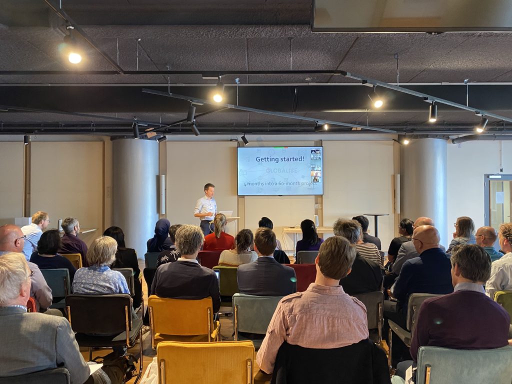
Getting started!